My Town - Main Street, Illinois USA
A GPS and Ecocaching Project
for Students and Schools Across Illinois

Objective:
To have each school locate their town’s geographic center and report what exists there for all to see. Students can also post additional information, pictures, sound files, and movies about their town that they want to share with other students across Illinois as an Ecocache Project.
Objective:
The main objective is to have the students give their town a “voice” for all to read about, hear and see.
Objective:
The information about their town’s geographic center will be posted at the www.ilega.org website as an Ecocache Project.
Equipment:
A GPS unit, camera, and creative students who want to give their community a voice and personality on the Web to share with other students across Illinois.
So what is an Ecocache?

An Ecocache is an educational virtual geocache that people can visit to view a unique feature. Ecocaching is the concept of treasure hunting for caches that the Community has to offer.

The concept of ecocache is derived from the term cology, more specifically human ecology, and it refers to any place where a historical, natural or cultural feature may be found on the landscape in their community.

Examples of ecocaches may include a natural levee, a particular habitat such as a flood plain forest, a viewing platform overlooking a wetland marsh, an historic building, ghost signs, a WPA mural in a post office lobby, or a prehistoric earthwork, each with its own story.

Used in this context, these features are "exhibits" in a museum without walls, each of which may be located and interpreted with GPS and/or MP3 technology.

Give a location in your area a voice as well as making your mark on the world for your community and school!

All you need to get started is something to share locally and a GPS receiver.

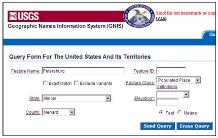
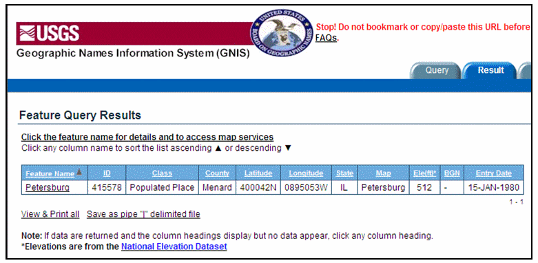
My Town - Main Street, Illinois USA

1. Find the geographic center for your town from the USGS.
    a. Go to: http://geonames.usgs.gov/pls/gnispublic/
    b. Enter your town name in the Feature Name field
    c. Select Illinois from the State field list
    d. Select your county from the County field list
    e. Select “Populated Places” from the Feature List field
    f. Click on the “Send Query” button.


2.     A new screen will show up listing your town plus other information.

3.     The data you want to use is the Latitude and Longitude fields.

4.     It might look a little strange but it is easy to translate.

5.     Latitude 400042N means 40 degrees, 00 minutes and 42 seconds North.

6.     Longitude 0895053W means 89 degrees, 50 minutes and 53 seconds West.

7.     You now have the geographic center of the town in Latitude and Longitude as determined
         by the USGS. From the data above you can see the date the data was entered.

8.     For this project you need to convert the Latitude and Longitude which in Degrees, Minutes,
         and Seconds to Degrees Minutes which most people use on their GPS units.

9.     Going back to the example above, if you take the coordinate 400042N and divide the last two
        numbers by 60, you will get the decimal minutes. So 42 divided by 60 = 0.700, (round to 3
       decimal places) which is the decimal minutes and gives us N 40° 00.700’. If you now take the
       other coordinate 895053W and divide the last two numbers by 60, you will get the decimal
       minutes. So .53 divided by 60 = 0.883, (round to 3 decimal places) which is the decimal minutes
       and gives us W 89° 50.883'.

10.   Using the converted Latitude and Longitude from the step above, you can go out and find
        the geographic center of your town. You might be surprised by its location! You will
        need a GPS unit for this part of the activity.

11.   The next step is to report back about your town and community. Besides reporting about
         what you found at your town’s geographic center, you should think about what unique features
         you want to share about your town. Research them, take pictures or movies or both, create
         a mp3 file as well as additional written documentation.

12.     After collecting and developing all the items you want posted, go to www.ilega.org and click on
         the My Town – Main Street link and follow the directions. Most of the information can
         be posted right on the page. Any files as related to pictures, movies, MP3 files as well as word
         documents can be sent via email or we can setup FTP access to handle larger files like movies.

My Town - Main Street, Illinois USA
Submission Page

Pictures, word files or pdfs, sound files and videos must be submitted by email!
We will be happy to post what your students created to give
your ecocache a location and a voice for all to read, hear and see!

The link to the form will be coming soon!
Email us if you find this project interesting!

Return to Main Page